I, for one, welcome our new Google overlords.
It seems that Google, in the pursuit of its inveterate yearning to make our lives as easy and effortless as possible, has thought of just one more little thing that will make all the difference in the world to us as we go out to catch live music or other performances, a delicious meal at a new restaurant our friends have been telling us about, or a sporting event, or a family member’s birthday party, or a business meeting in a busy area of town, or, or, or…
To help us solve one of the most common IRL problems faced by people who live in or around big metro areas (parking!), the Internet search and advertising giant has now added a special parking icon to the latest version of the Google Maps Android app.
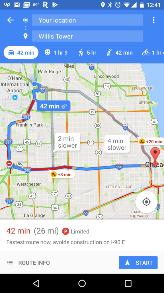
Google Maps’ new on-site parking difficulty icon will tell you how easy or difficult it will probably be to find on-site parking at your destination. Google wants to help you factor in how much time to allow yourself to park when you get where you want to go.
This new Google Maps feature will be available for 25 metro areas throughout the United States, including: San Francisco, Seattle, Los Angeles, San Diego, Portland, Sacramento, Miami, Atlanta, Boston, Charlotte, Chicago, Detroit, Minneapolis/St. Paul, New York City, Orlando, Philadelphia, Pittsburgh, St. Louis, Tampa, Washington, DC, Cleveland, Dallas/Fort Worth, Denver, Houston, and Phoenix.
The new functionality will deliver its results using predictive data, similar to how Google Maps calculates peak traffic times for popular venues. Google Maps says it will make use of “historical parking data” to determine one of three parking difficulty scores, which will then be displayed in Google Maps’ directions display for a given destination as “Limited,” “Medium,” or “Easy,” based on the day and time, and historical parking data for the area.
This is just one more example of how Google / Alphabet is beginning to leverage the incredible potential of Google Maps’ massive install base and the data generated by its users to innovate new functionalities that help users to better understand what to expect once they reach their destination.
As referenced above, Google has already been using location data and searches (anonymized so it can’t be traced back to you specifically) to offer a “Popular Times” feature since November, which helps Google Maps users see when a business or venue is most likely to be crowded so you can avoid the rush hour, or weigh how badly you want to go there at a given time against how long you’re willing to wait to be served.
The new on-site parking feature may end up serving results based on dynamic information soon enough. The Popular Times tool, which has been added to both Google Search and Google Maps, which also started off using historical data, now works in real-time.